OpenVPS
The open spatial web starts here
OpenVPS is the open-source Visual Positioning Service reference implementation from Open AR Cloud. It follows the OGC GeoPose standard and the OSCP GeoPoseProtocol so any compliant client can self-host camera-based 6DoF localization without vendor lock-in, without proprietary APIs, and without data leaving your server.
Built by Nokia Bell Labs for OARC Europe and funded through NGI Atlantic and NGI Search.
What It Is
OpenVPS is a batteries-included research and deployment foundation not a managed cloud product. It is designed for teams that need full control over their localization infrastructure.
- No vendor lock-in built on open standards that any compliant client can speak.
- No proprietary APIs the GeoPoseProtocol is public and documented.
- No data leaves your server maps, imagery, and query data stay on infrastructure you control.
- Complete pipeline integrates capture, feature mapping, geo-alignment, and localization in one system from the first scan to a live GeoPose response.
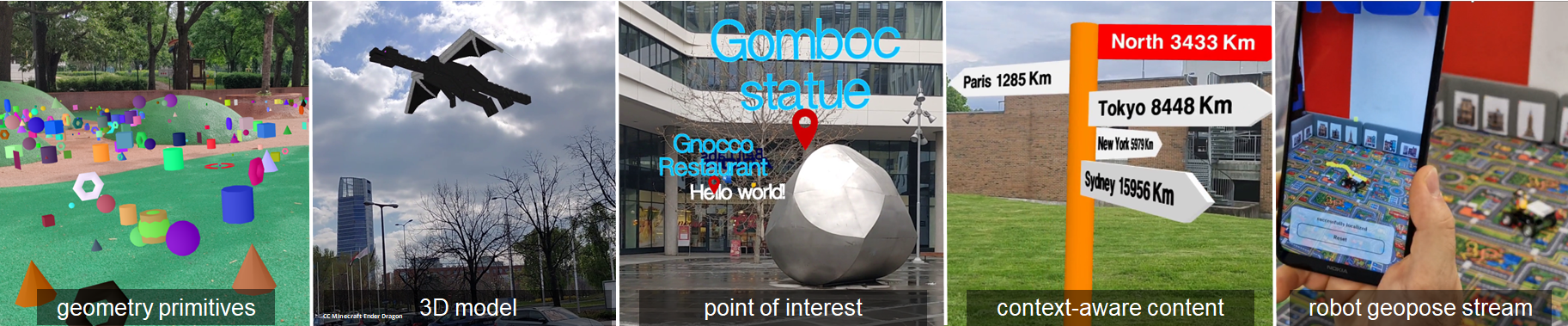
The spARcl spatial browser is the reference client for OpenVPS, demonstrating geometry primitives, 3D models, points of interest, context-aware content, and robot geopose streams.
How It Works
- Capture Use the StrayScanner or Android Kapture app to collect RGB, depth, GPS, and sensor data.
- MapBuilder Run the HLOC pipeline to generate a feature map from the captured imagery.
- MapAligner Align the feature map to OpenStreetMap footprints and produce the geo-alignment transform.
- MapLocalizer Receive the camera image and coarse location, then return a GeoPose response for OSCP clients.
Origin Story
Phase 1 Aurora Viewer, NGI Atlantic (2022)
Open AR Cloud Europe, George Mason University, 3DInteractive, and COSMOS Lab demonstrated the first open-source VPS reference deployment on a 5G testbed. That phase proved the OSCP concept end-to-end.
Phase 2 OSCAR4US, NGI Search (2024–2025)
Nokia Bell Labs built the current OpenVPS stack for OARC Europe, including MapBuilder, MapAligner, MapLocalizer, and the GeoPoseProtocol compliance layer. That phase turned the proof of concept into an experimental testbed for anyone interested in location-based augmented reality.
Credits
- Dr. Gabor Soros Senior Research Scientist at Nokia Bell Labs and technical architect of the OpenVPS implementation.
- Dr. Denes Bisztray Senior Research Engineer at Nokia Bell Labs and core implementation contributor.
- Andor Kovacs Nokia Bell Labs intern and contributor to the OpenVPS implementation.
- Asmaa Thabet Nokia Bell Labs intern and contributor to the OpenVPS implementation.
- Alina Kadlubsky Managing Director of Open AR Cloud Europe.
Ecosystem
OpenVPS fits into the broader open spatial web stack:
Just as the web needed standards, protocols, services, discovery, and browsers, the spatial web needs the same layered model. OpenVPS is the localization backbone in that stack.
The full source code is available on GitHub.
Get Involved
We are looking for OpenVPS partners educational institutions, tech centers, students, and professors to continue building this initiative for the benefit of all.
If you are interested in getting involved, become a member and we will reach out to onboard you to our team.
If you have questions, write to us and we will invite you to one of our bi-weekly working group meetings, introduce you to the team, and give you an update on Open AR Cloud and the OpenVPS initiative.